Regions of the United States: the 4 Regions and 50 States
Last reviewed: October 31, 2026
The United States has four official regions, defined by the Census Bureau: the Northeast (9 states), the Midwest (12), the South (16 plus Washington, D.C.) and the West (13). Schools often teach a five-region version instead, which adds the Southwest. Here is every state by region.
| Region | States | Which ones |
|---|---|---|
| Northeast | 9 | Connecticut, Maine, Massachusetts, New Hampshire, Rhode Island, Vermont (New England) · New Jersey, New York, Pennsylvania (Mid-Atlantic) |
| Midwest | 12 | Illinois, Indiana, Michigan, Ohio, Wisconsin (East North Central) · Iowa, Kansas, Minnesota, Missouri, Nebraska, North Dakota, South Dakota (West North Central) |
| South | 16 | Delaware, Florida, Georgia, Maryland, North Carolina, South Carolina, Virginia, West Virginia + Washington, D.C. (South Atlantic) · Alabama, Kentucky, Mississippi, Tennessee (East South Central) · Arkansas, Louisiana, Oklahoma, Texas (West South Central) |
| West | 13 | Arizona, Colorado, Idaho, Montana, Nevada, New Mexico, Utah, Wyoming (Mountain) · Alaska, California, Hawai'i, Oregon, Washington (Pacific) |
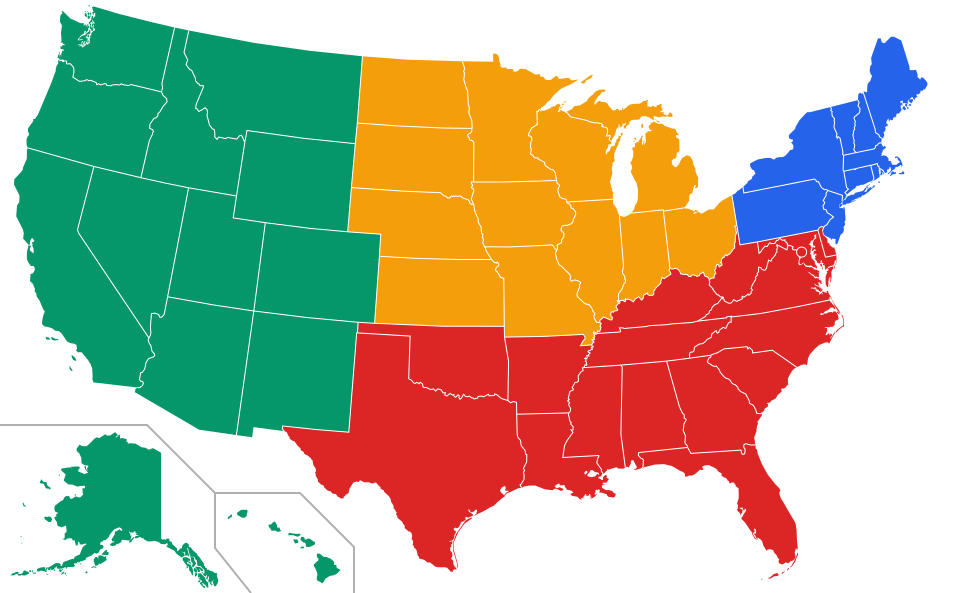
To explore the same breakdown, our interactive map of the 50 US states by region colors every state by its Census region and lets you filter by region, postal abbreviation or capital. For capitals, see US states, capitals and abbreviations.
The 5 regions of the United States taught in schools
Many American classrooms divide the country into five regions rather than four, and this is what a worksheet asking for the "Southeast" or "Southwest" has in mind. This grouping is a teaching convention, not an official one, and textbooks differ on some border states. A common version:
| Region | States | Which ones |
|---|---|---|
| Northeast | 11 | Connecticut, Delaware, Maine, Maryland, Massachusetts, New Hampshire, New Jersey, New York, Pennsylvania, Rhode Island, Vermont |
| Southeast | 12 | Alabama, Arkansas, Florida, Georgia, Kentucky, Louisiana, Mississippi, North Carolina, South Carolina, Tennessee, Virginia, West Virginia |
| Midwest | 12 | Illinois, Indiana, Iowa, Kansas, Michigan, Minnesota, Missouri, Nebraska, North Dakota, Ohio, South Dakota, Wisconsin |
| Southwest | 4 | Arizona, New Mexico, Oklahoma, Texas |
| West | 11 | Alaska, California, Colorado, Hawai'i, Idaho, Montana, Nevada, Oregon, Utah, Washington, Wyoming |
Four regions, nine divisions
The Census Bureau divides the country into 4 regions and 9 divisions. This is the official grid used for national statistics, and it is also the one most textbooks adopt.
- Northeast: New England + Mid-Atlantic.
- Midwest: East North Central + West North Central.
- South: South Atlantic + East South Central + West South Central.
- West: Mountain + Pacific.
How big is the United States?
The country covers roughly 3.8 million square miles (about 9.8 million km²), nearly the size of all of Europe. That scale explains why it holds several climates, political cultures and accents, and why generalizing about "Americans" so often fails. The South is the most populous of the four regions, while the Northeast is the smallest in area and the most densely settled. Below, each region in turn, then a few sub-regions that often say more than the official grid.
The Northeast
The Northeast brings together the northern colonies among the original Thirteen: New England (Maine, Vermont, New Hampshire, Massachusetts, Rhode Island, Connecticut) and the Mid-Atlantic (New York, New Jersey, Pennsylvania). It is the most densely populated and most urbanized region, with a nearly continuous corridor from Boston to Washington sometimes called the Bos-Wash megalopolis.
Climate: humid continental, with cold winters and hot, muggy summers. Fall foliage is dramatic, especially in the Appalachians and Vermont. Economy: finance (New York), higher education (Boston, Cambridge, New Haven, Princeton), and federal administration (around D.C., which the Census places in the South region but which culturally belongs to the Northeast corridor as well). Politics: broadly more left-leaning than the national average, with strong rural/urban nuances.
The South
The South, in the Census sense, is the most populous region. It covers a very wide band, from the South Atlantic (Delaware, Maryland, Virginia, West Virginia, North Carolina, South Carolina, Georgia, Florida, plus the District of Columbia) to the East South Central (Kentucky, Tennessee, Alabama, Mississippi) and the West South Central (Arkansas, Louisiana, Oklahoma, Texas).
Climate: varied, from humid subtropical in Florida and south Texas to the colder Appalachians in the north. Hurricane season affects the Atlantic and the Gulf of Mexico. Economy: energy (Texas, Louisiana), aerospace (Houston, Florida), financial services (Charlotte), entertainment (Atlanta, Nashville), and intensive agriculture. Culture: a strong religious tradition, a recognizable accent, distinctive cuisine (BBQ, soul food, Creole), and community life structured by churches and college sports (NCAA football).
The South also carries most visibly the memory of the Civil War and segregation, and remains a closely studied political ground for understanding the country's racial history.
The Midwest
The Midwest, sometimes called "the heartland" by its residents, covers the great grain plains and the Great Lakes region: East North Central (Ohio, Indiana, Illinois, Michigan, Wisconsin) and West North Central (Minnesota, Iowa, Missouri, North Dakota, South Dakota, Nebraska, Kansas).
Climate: continental, with very cold winters and hot, stormy summers; Tornado Alley runs through the central Plains (from Texas and Oklahoma to Kansas and Nebraska). Economy: large-scale agriculture (corn, soybeans, livestock), the auto industry around Detroit, steelmaking along the Great Lakes, food processing in Chicago, and medical technology in Minneapolis–Saint Paul. Culture: a reputation for reserved civility (Midwestern nice), strong local pride, omnipresent college sports (Big Ten), and community life built around small towns and counties.
The West
The West splits between the Mountain sub-region (Montana, Idaho, Wyoming, Nevada, Utah, Colorado, Arizona, New Mexico) and the Pacific sub-region (Alaska, Hawai'i, Washington, Oregon, California). It holds the greatest geographic diversity: the deserts of the Southwest, the high plateaus of the Rockies, the rainforests of the Pacific Northwest, the Mediterranean coasts of California, the archipelagos of Hawai'i, and the taiga and tundra of Alaska.
Climate: extremely varied, from the scorching summers of Phoenix (where highs near 120 °F / 49 °C have been recorded) to the wet winters of Seattle, the heavy snowfall of Utah, and the altitude of Denver (the "Mile High City"). Economy: tech (Silicon Valley, Seattle), energy (Wyoming and New Mexico are major centers), tourism and national parks (Grand Canyon, Yellowstone, Yosemite), and intensive irrigated agriculture in California. Culture: more secular on average, a persistent pioneer spirit, a significant presence of Hispanic, Asian, and Native American cultures, and deeply rooted outdoor habits (hiking, skiing, surfing).
Sub-regions sometimes more revealing than the official grid
Beyond the Census breakdown, Americans speak daily of finer cultural zones:
- New England: the six historic northern states.
- Deep South: Alabama, Mississippi, Georgia, Louisiana, South Carolina — where Southern culture is most pronounced.
- Bible Belt: a belt running roughly from Tennessee to Texas, with a particularly strong Protestant religious weight.
- Rust Belt: the former industrial zone of the Midwest and western Pennsylvania, marked by deindustrialization.
- Sun Belt: a wide southern band running from Florida to California, with sustained population growth.
- Pacific Northwest (PNW): Oregon, Washington, sometimes northern California; an environmental and tech identity.
- Southwest: Arizona, New Mexico, southern Nevada and Utah; deserts, strong Hispanic and Native American influences.
Climate and physical geography
- Major landforms: the Appalachians in the east, the Rockies in the center-west, the Sierra Nevada and the Cascades on the west coast.
- Hydrography: the Mississippi–Missouri basin (the 4th largest in the world), the Great Lakes, the Colorado, the Rio Grande, the Columbia.
- Coasts: the Atlantic, the Gulf of Mexico (renamed the Gulf of America by the US federal government in 2025), the Pacific, and the Arctic in Alaska. Nearly 95,000 miles of shoreline in total.
- Climate hazards: hurricanes in the Southeast and the Gulf, tornadoes on the Plains, earthquakes in California and Alaska, wildfires in California and the Northwest, snowstorms ("nor'easters") in the Northeast, droughts in the Southwest.
Time zones
The continental United States has four main time zones: Eastern (UTC−5, or −4 in summer), Central, Mountain, and Pacific. Added to those are Alaska (UTC−9) and Hawai'i (UTC−10), the latter not observing daylight saving time. When it is noon in London, it is 7 a.m. in New York, 6 a.m. in Chicago, 5 a.m. in Denver, 4 a.m. in Los Angeles, 3 a.m. in Anchorage, and 1 a.m. in Honolulu (during summer time, when Hawai'i stays on standard time).
How to read the news with these regions in mind
- A climate policy will hit the West (drought, fires), the South (hurricanes), and the Midwest (tornadoes, agriculture) very differently.
- An immigration reform primarily concerns the southern border (Texas, Arizona, New Mexico, California) and the major arrival cities.
- A trade decision affecting the auto industry weighs most heavily on Michigan, Ohio, and Indiana.
- Rising rents are felt above all in the coastal metros and across the Sun Belt (Austin, Phoenix, Miami).
Frequently asked questions
How many regions does the United States have?
The U.S. Census Bureau officially recognizes four regions — Northeast, Midwest, South, and West — further subdivided into nine divisions. These are statistical groupings, not levels of government, and Americans also use many informal sub-regions (Deep South, Sun Belt, Pacific Northwest, and so on).
Which is the largest and which is the smallest U.S. state?
Alaska is by far the largest state at about 663,000 square miles, while Rhode Island is the smallest at roughly 1,545 square miles. By population, California leads (around 39 million) and Wyoming has the fewest residents (around 580,000).
What are the 5 regions of the United States?
The five-region version taught in many schools is the Northeast, Southeast, Midwest, Southwest and West. It is a teaching convention; the official Census Bureau grid has four regions.
Which states are in the West region?
The Census West has 13 states: Alaska, Arizona, California, Colorado, Hawai'i, Idaho, Montana, Nevada, New Mexico, Oregon, Utah, Washington and Wyoming.
How many time zones are there in the United States?
The continental U.S. uses four time zones (Eastern, Central, Mountain, Pacific), with two more for Alaska and Hawai'i. Counting the territories, the country spans nine official time zones, but for the 50 states the practical answer is six.
What is the difference between the South and the Deep South?
The "South" is the broad Census region stretching from Maryland to Texas. The "Deep South" is a smaller cultural core — typically Alabama, Mississippi, Georgia, Louisiana, and South Carolina — where Southern history, accent, and traditions are most concentrated.
Related articles: